Although every square metre of land located on both sides of the Saigon River is currently evaluated at top prices and occupied by hundreds of real estate developers, the city still does not have a master plan to develop methodically and effectively this golden land area.
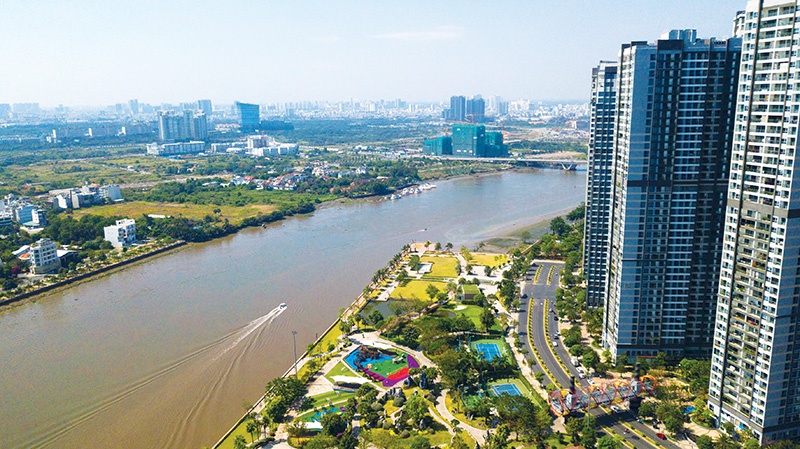
Ho Chi Minh City authorities see the potential of geography that can match the likes of Seoul or London, Photo: Le Toan
Recent years are being considered as successful ones for high-class riverside real estate in Ho Chi Minh City, with the banks of the Saigon River now boasting many large-scale projects.
From Saigon Bridge in Binh Thanh district to Tan Thuan Bridge in District 4, hundreds of buildings are already built or are in construction. Besides big urban areas that have been put into use, such as Vinhomes Central Park and Sala urban area, a series of significant projects will be deployed over the next few years such as the Park of Bach Dang Wharf, Nha Rong-Khanh Hoi Complex Area, and many others.
One of the largest ventures along the sides of the Saigon River is the construction of technical infrastructure for Mui Den Do Park and an urban housing area. The total area of the planned project is about 117 hectares, including a multipurpose mixed park of about 82ha and a residential area of about 35ha, including the most high-end resorts, financial centres, hotels, and entertainment area of Ho Chi Minh City. The total investment is estimated at $6 billion.
When this series of massive projects along the sides of the Saigon River is completed and put into use, it will bring a completely new look to Ho Chi Minh City and help it play the part of a true financial centre. It is hoped that by the next decade, the centre will no longer focus only on District 1 but will spread along the two sides of the Saigon River like the development trend of cities with world-famous rivers like the Han River in Seoul or the Thames in London.
Nguyen Huong, CEO of Dai Phuc Land, said that this development can create a powerful driving force for economic and social development. However, the development of both sides of the river is still too fragmented, asynchronous, and much behind the potential and position of a leading economic city, the most populous in the country.
Prioritising development in Ho Chi Minh City
In the five areas of the planning zone, the section on the east bank from Saigon Bridge to Diamond Island Bridge and the section from Saigon Bridge to Tan Thuan Bridge on the west side will be the central area with potential for developing commercial activities and services.
Ho Chi Minh City People’s Committee will prioritise the development of this area to build connectivity and synchronous infrastructure, including river embankments, wharves, walking routes, bicycles, transit stations, green parks, and urban squares. These will be implemented through pilot models of some outstanding projects this year to gain experience and replicate across the whole area. Source: Ho Chi Minh City Department for Planning and Architecture
A master plan in need
Along the Saigon River there is no cross-traffic corridor, but only intermittent sections. Huong took the example of Danang, which has done a great job creating an arterial traffic route along the Han River, creating a spectacular change and rapid development of the two riverside areas of the whole city. “We can develop the two sides of the river successfully only if we have a master plan to develop it, to attract more investors into real estate projects located in the area,” Huong said.
Waterway traffic meanwhile has not been promoted. In addition to river bus routes and sightseeing boats that were put into operation some months ago, mainly serving tourists, the river has not been recognised to exploit the value of waterway traffic properly, while the roads are becoming overloaded and it is too expensive to expand new routes.
The policy of using the land bank along the Saigon River has always been a concern for many years of Ho Chi Minh City’s leaders, experts, and the public.
The plan on river embankment development and riverside service economy in Ho Chi Minh City for the 2020-2045 period was approved last year by the people’s committee, and it is expected to be a golden opportunity for developing the city in that time. The committee emphasised the vision to develop the Saigon River corridor and inner-city canals to promote the city’s cultural, historical, and biological values.
The Saigon River is divided into two areas, including the upstream area from Dau Tieng Lake to Phu Long Bridge, and District 12 and the middle and downstream area from Phu Long Bridge to the confluence of Mui Den Do Park. The middle and downstream areas are divided into a further five regions with corresponding solutions set out in the plan.
Greener integration
Ho Chi Minh City’s orientation is to gradually build and complete a multi-functional infrastructure system along the banks of the Saigon River, organise an architectural space connecting public utilities, and create favourable conditions for the development of commercial activities related to green water infrastructure.
According to Ho Chi Minh City People’s Committee, from now to 2025 the city will implement an action programme to renovate and embellish the Saigon River corridor, and will promulgate and implement regulations and guidelines for the management and development of river corridors. Along with that, many typical projects on investment in integrated green infrastructure associated with tourism activities and entertainment services will also be implemented.
From 2025 through to 2045, Ho Chi Minh City will implement green infrastructure investment projects integrated with tourism activities and economic and entertainment services.
Architect Ngo Viet Nam Son, chairman of Ngo Viet Architects & Planners, said that the current development plan for both sides of the river is not equal enough for a metropolis like Ho Chi Minh City.
“The current development is scattered and has not created an ideal public space for all people. The proposed master plan must evaluate the scale of the land fund located along the two sides and set up a framework to connect transport systems,” Son said.
Vo Kim Cuong, former deputy chief architect of Ho Chi Minh City, said that a policy on disclosure that effectively exploits the riverside land fund, letting local people participate in this process and benefit, should be designed. “Both the state and local people will benefit if we have a suitable policy in which people do not have to move to another place, but in which living conditions are improved,” said Cuong.
Source: VIR.